Bullhead city, mohave sun valley airport
The Favorite Bullhead City Airport Flight Map Photos Contact Us Check Fuel Prices


Flight Map

flight map
Map courtesy of Airguide Publications, Inc.
http://www.flightguide.com

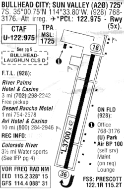
FAA Identifier A-20
Paved and Lighted 3,700 foot long Runway
Pilot Controlled Landing Lights
Fuel Available: 100 Octane LL  - $2.60 gallon

Geographic Data
Latitude: N3500.8   Longitude: W11433.8 (ESTIMATED)
Arpt Elevation: 725 ft ( ESTIMATED)
Magnetic Variation: 14E
7 miles S of BULLHEAD CITY
Sectional Chart: PHOENIX

More flightplan info: http://www.fltplan.com/AirportInformation/KA20.htm


COPYRIGHT © 2004-2005 BULLHEAD CITY AIRPORT
INFO@BULLHEADCITYAIRPORT.COM